Take your Operation to New Heights with PLM Drone Data Management
When it comes to making effective, cost-saving decisions for your operation, PLM Drone Data Management gives you the tools needed to make timely agronomic decisions.
PLM Drone Data Features
- Industry-leading analysis tools and app marketplace
- Save imagery as Shapefile or GeoTIFF
- Export data to PLM Mapping
- Capable of data sharing
Advantages
- Pinpoints potential problems in areas in your field with GPS location
- Flight operations, imagery upload, and analysis is completed in a single tool
- No manual flying is required
- Imagery is uploaded in minutes
Real World Applications
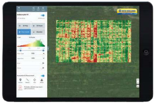
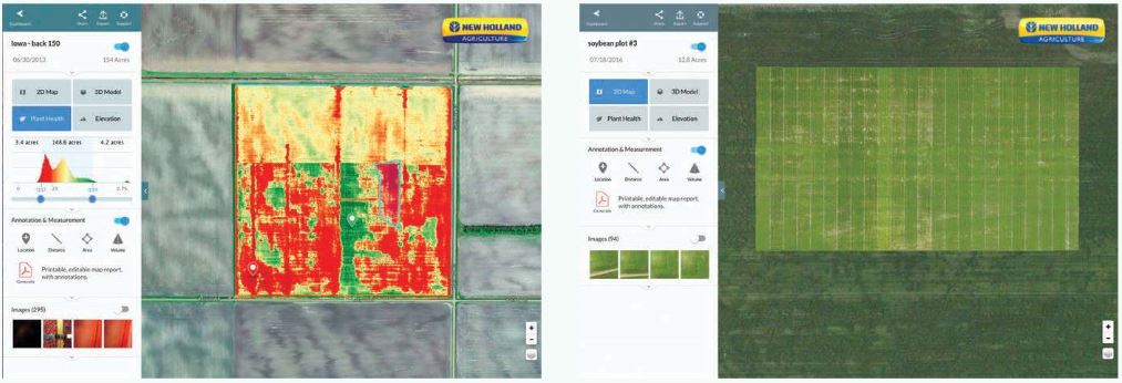
- Crop scout to detect plant health problems: Drone mapping helps pinpoint the location and extent of plant health issues, which are illustrated through the DroneDeploy dashboard.
- Plant counts and stand establishment: Drones can help compile automated plant count reports of entire fields. Stand establishment of newly planted crops can also help growers decide whether they need to replant certain areas.
- Generate variable-rate prescriptions: Drone-generated shapefiles from DroneDeploy can be exported into popular farm software to assist with creating variable-rate prescriptions for nitrogen, pesticides, and other targeted nutrient applications.
- Negotiate fair crop loss percentages: Annotated crop health maps help users with insurance requests and recouping crop losses.
- Assess and clean up after natural disasters: Drone maps can help estimate the extent of storm or tornado damage, and even help when clean-up is needed. A drone map can spot hidden debris, enabling users to plan for more efficient removal.
- Water Management Assessment: Drone maps can assist in planning for drainage tile placement and help assess a water management system’s effectiveness.
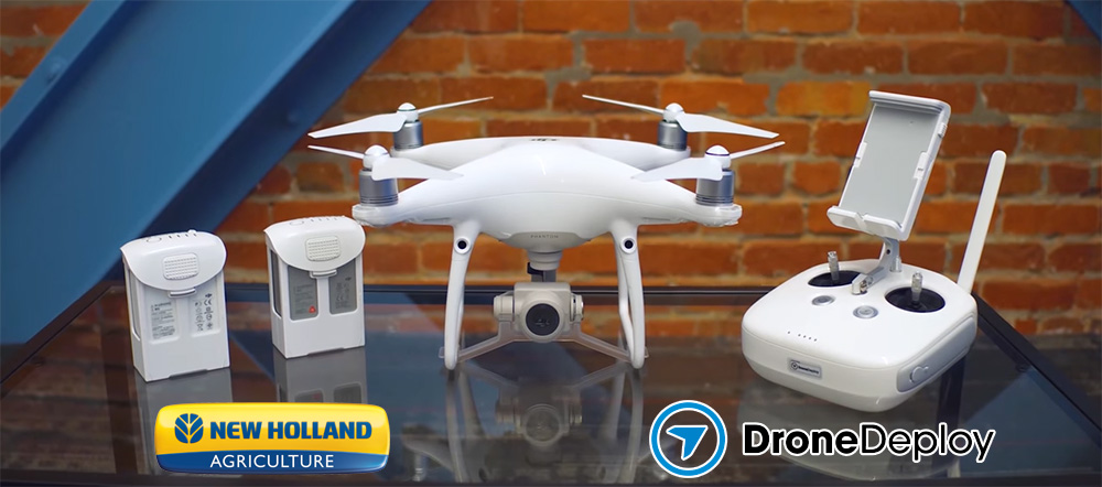
The PLM Drone Data Management Package with Fieldscanner Includes:
- DJI® Phantom 4 Pro drone with RGB camera and remote controller
- Hard-sided carrying case
- Accessories including 2 batteries, standard battery charger (simultaneously charges 1 battery and remote controller), cables, mounts, and Micro SD Card
- One-year subscription to DroneDeploy®
- Premium or standard software
Software that is Field Tested and Farmer Approved
New Holland has collaborated with DroneDeploy® to provide you with UAV Software that is innovative, industry leading, and easy to use. To ensure that your drone is never grounded, we offer support by email, phone, and live chat, giving you the choice of the support style that is most convenient for you.
| Available Software Packages: | Standard | Premium |
|---|---|---|
| Max 2D Resolution | 2 cm / Pixel | 1 cm / Pixel |
| Max Photo Upload per Map | 1,000 | 3,000+ |
| Subscription Length | 1-Year | 1-Year |
| Drone Model | DJI® Phantom 4 Pro | DJI® Phantom 4 Pro |
| Includes | 2 batteries, hard shell case, and RGB camera | 2 batteries, hard shell case, and RGB camera |
A buyer should choose Premium, instead of Standard if they plan to:
- Generate standard maps of over 200 acres per field at high altitudes
- Generate stand establishment, plant count, crop damage, or other specialized reports of over 100 acres per field
Compatibility
This is an All-Makes Compatible Product:

Contact Ag Technologies (1268 E 100 S Rochester, IN 46975) at 574-223-8324 for more information!